In the North
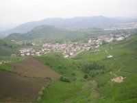
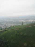
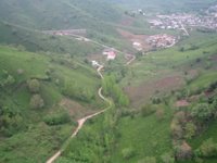
I have been to the North for a couple of days recently. Our northern provinces are three (Guilan, Mazandaran, Golestan) and consist a rim adjacent to Caspian Sea. When the whole country is classified as 'semi-arid', they are humid, with a high rate of rain fall, totally green and different from rest of the country. The North is squeezed between Caspian Sea on northern side and Alborz mountains in the south. That's the reason the vapors are trapped over there and give a special climate to it. For many Iranians who are deeply in love with greenery, the North has always been a favorite recreational destination. Sandy seashores, nice weather, amazing green-covered mountains, forests and villages here and there are of the places the people take refuge to escape from messy urban life.
Beside some factories in center of the provinces, the economy of the region is mostly based on farming, husbandry and fishery. Iranians are rice-eaters and most of the rice in the country is produced in this region. When you move from east toward the west of the rim, you will see rice fields stretched toward the mountains. On the slopes there are tea farms. Fishery dates back to hundreds of years ago. Iranian caviar which the country is famous for is fished in Caspian Sea.
The pictures are taken from a cable car in Lahijan. These pictures are for those viewers who think that our country is just deserts and the only vehicle we drive is camel. :)
Geological map of Iran: the green line in the north is the three provinces.
posted by Laila @ 9:17 AM
0 comments
![]()

0 Comments:
Post a Comment
<< Home